
Dogsled, snowmobile, or chartered helicopter—if you want to get around Kamchatka during winter, those are your options. Kamchatka Peninsula, which curves down from the Russian mainland like a broad cutlass, is flanked to the west by the Sea of Okhotsk. To the east is the Bering Sea, then the gentle arc of the Aleutian Islands and Alaska. “Remote” doesn’t begin to describe Kamchatka. It’s nine time zones from Moscow—Russians call it the caboose—and though it’s close in size to California, only 400,000 people hang their hats there.
Maybe that’s for the best. Kamchatka is literally bursting with active volcanoes, including Kluchevskoi, the largest active volcano in Eurasia and one of the largest in the world, and Karymsky, which has been erupting reliably for the past five years.
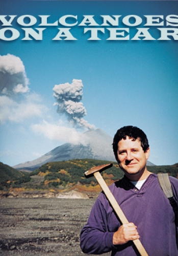
It’s a volcanologist’s dream. When Jonathan Lees first visited Kamchatka in 1996, his Russian colleagues took him up in a helicopter for a bird’s-eye view of Karymsky volcano. Lees, associate professor of geological sciences, didn’t know at the time that Karymsky was active.
“As the helicopter swung around,” Lees says, “this explosion came right up in our faces. I’d never seen that before, and I thought it was pretty cool. When I say ‘pretty cool,’ I mean that our mouths were open, and our eyes were popping out of our heads.”
So Lees set up an array of seismic instruments on Kamchatka. What he found might change the way scientists think about the Earth’s crust.
Kamchatka sits at the junction of the Pacific and North American plates, two of the rigid slabs that make up the Earth’s crust. Each year, as the Pacific plate moves a few inches west and northwest, it bumps up against the North American plate (which, despite its name, includes Kamchatka and quite a bit of the northwest Asian continent).
The two plates differ in thickness and density—oceanic plates such as the Pacific are heavy and thin, while continental plates are lighter and thicker—and when they come together, the Pacific plate subducts, or slides under, the North American plate.
Because it’s been under the ocean for millions of years, the Pacific plate is covered with a layer of water-saturated sediment, which sinks into the Earth’s mantle as the Pacific plate subducts. “This watery sediment lowers the melting temperature of the mantle,” Lees says. “The mantle starts to boil, and then it comes to the surface as magma.”
The magma either pools below the surface or erupts as lava. That, in a nutshell, is subduction-zone volcanism. But in Kamchatka, things aren’t quite that simple.
The Pacific plate’s northern edge runs in an east-to-west arc that roughly follows the Aleutian islands. Just off Kamchatka, however, this edge turns abruptly south toward Japan, giving the plate a sharp northwest corner. Seismic data tell us that the northern edge of the plate subducts to the north, beneath the Aleutians, and that the western edge of the plate subducts to the west beneath Kamchatka. But scientists have long puzzled over how the plate behaves at the northwest corner (click here for a diagram).
There are at least two possibilities: the plate could stretch around the corner, like a tablecloth draped over a table corner. Or, the plate itself could have torn to accommodate the corner. (Take one corner of our tablecloth and rip upward for a few inches.)
Lees believes that the latter model—he calls it the tear model—is correct. But seismologists can’t just peel open the Earth to prove their theories. Instead, they rely on computers to interpret data recorded by processes such as Computer Aided Tomography (CAT).
In much the same way doctors use x-ray CAT scans to see inside the body, seismologists use earthquake waves to map out perturbations inside the Earth. “In the lab you can shoot x rays from any and all angles,” Lees says. “In the Earth we have a problem because we don’t control where the sources are—we put the seismic stations out where we can, and then the earthquakes occur where they occur.”
Since Kamchatka is so far off the beaten path, setting up seismic stations was a challenge. “You deploy along the road if you can,” Lees says. “If you deploy away from the road, you have to pay for a helicopter.” Then you leave, and hope that no passerby takes a shine to your equipment—ongoing Russian energy shortages make the seismic stations’ solar panels and auto batteries especially attractive to locals.
“Most of the time that I worked in Kamchatka,” Lees explains, “there was no hot water—and often no electricity.” After weeks of field work with nary a shower in sight, Lees was more than happy to jump into one of Kamchatka’s hot—and muddy—springs.
And let’s not forget the bombing range. For years, the Russian military has used much of Kamchatka’s wilderness interior as a target for missiles launched from the mainland. So the Russian government wasn’t keen on Lees setting up his instruments there. “Not because they were worried about us,” Lees says, “but because they didn’t want us to know where these things land. They think that if we’re listening to the ground shaking, we can estimate how big a missile was, and—well, they’re kind of spooked.”
Bombs and battery thieves notwithstanding, Lees was able to get a pretty good idea of how the Pacific plate behaves just off Kamchatka. If the Pacific plate were torn, Lees reasoned, the edges of that tear would be exposed to the hotter underlying mantle as the plate subducts. The mantle material would flow around those torn edges and gradually erode the subducting crust, or “slab,” as seismologists call it.
Lees analyzed his data using software he developed as a graduate student and found strong evidence to support his tear model. Earthquakes that occurred close to the edge of the slab were much more shallow than those occurring toward the slab’s middle. Why? Lees figured it’s because the edges of the slab are no longer there—they’ve been eroded by the mantle.
Later, at a conference, Lees heard a presentation by Gene Yogodzinski of Dickinson College in Pennsylvania. A geochemist, Yogodzinski studies the chemical makeup and changes of volcanic rocks and the like. Yogodzinski showed Lees geochemical data from two distinct groups of volcanoes on Kamchatka—one northern, one southern. The southern volcanoes exhibit normal geochemical signatures. But the northern volcanoes are spewing adakites—bits of hardened lava that contain material from the slab. “The northern volcanoes are right above where the slab edge is exposed, so little pieces of the slab are getting sucked up into this volcanism,” Lees says.
Adakites were first discovered about 20 years ago, east of Kamchatka on Adak Island in the Aleutians. They’ve since popped up all over the world. But scientists haven’t really agreed on how adakites form. Some researchers feel that certain areas of the slab are young enough, and therefore warm enough, to melt into magma. That couldn’t have happened around Kamchatka, where the slab appears to be too old and cool to melt.
But if the crust were torn, and the edges of that tear were eroded by the mantle? That would explain adakites nicely. So Yogodzinski and Lees detailed their findings in a paper that appeared in the January 25, 2001, issue of Nature.
How does the slab tear? “We assume slabs tear when stresses in the mantle are large,” Lees says. Mantle stresses may increase if a plate changes directions or deforms when colliding with another plate.
All of this may change the way seismologists and geochemists think about the Earth. “If you have tears in the slab, and the edges are being eroded like I suggest, then that will make all kinds of funny patterns in the mantle—things we’re not even taking into account now,” Lees says. “Most researchers study slabs in the middle of subduction zones. That’s a two-dimensional problem. Now we’re saying that we need to think of it as a three-dimensional problem.”
Lees is now turning his attention toward Strombolian volcanoes—in which a series of closely spaced eruptions occur over a long period of time—in Stromboli, Italy, and in Ecuador. And Lees isn’t finished with Kamchatka—with any luck, he’ll go back. Here’s hoping there’s hot water next time.
This research was funded by the National Science Foundation. Lees participates in the Carolina Speakers Program; for information, click here.