

When Lara Wagner started showing up on people’s doorsteps in the spring of 2009, it’s pretty likely that she was the first seismologist folks had seen in western North Carolina.


For many seismologists, “the East coast is kind of the ugly stepchild of the country,” Wagner says. Scientists who study the movement of the earth tend to gravitate toward places such as the Rocky Mountains or the eight hundred miles of the San Andreas Fault in California. The eastern half of the country gets a lot less attention.
“For a long time, the story has been that there isn’t anything to find,” Wagner says. The ground under the eastern seaboard is relatively stable, and the Appalachian Mountains are about four hundred million years older than the more active Rockies.
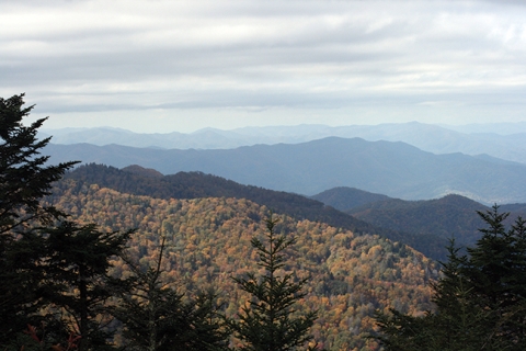
But when Wagner visits the Blue Ridge in North Carolina, the story she hears is different. “People will tell you that there are earthquakes all the time. Little ones: glasses clink, someone’s favorite plate falls off the wall. An old timer might tell you about a few larger ones.”
Scientists can’t explain why these quakes happen, because they just don’t know all that much about the lithosphere — the top layers of the earth that can be anywhere from about 15 to 185 miles thick — under this part of the country.
And the mountains aren’t the only place in the East where the earth moves: rare, larger earthquakes can happen in unexpected spots. In 1886 a quake that modern seismologists estimate was a magnitude 7.0 or 8.0 leveled Charleston, South Carolina. An 8.0 earthquake doesn’t surprise scientists when it happens on one of the faults between Earth’s tectonic plates — but on the eastern U.S. coast, well inside the borders of the North American plate? “There’s no reason that we know of for there to be an earthquake of that size,” Wagner says. “We’d like to have explanations for the activity we see here, and for those rare freak events.”
Seismologists look for these answers in the lithosphere, which is divided into tectonic plates that bump up against each other, scraping past or forcing each other up or down. Sometimes, pressure inside a plate makes the rocky top of the lithosphere bulge up. “It’s sort of like taking a notebook and bending it just slightly,” Wagner says, holding one up and pressing on the edges so that the center rises. That bulging pressure is what some scientists have thought could be supporting the Appalachian Mountains.
Mountains don’t stay the same year after year: they erode. In fact, scientists estimate that most mountains would erode after about 90 million years if they didn’t have more mass slowly coming up from the ground underneath. The Appalachians have been around for about 450 million years and they’re still good-sized mountains, so they must be getting more mass from underground. But Wagner is the first person to put broadband seismometers in the Appalachians to find out how this happens. The evidence is in the thickness of the crust under the mountains: a thin, flexed crust would tell her that the high pressure hypothesis was correct. A deeper crust would suggest that the Appalachians are like big icebergs, with lots of mass underneath, Wagner says. “You see the tiny tip of the iceberg, and if you scrape off the top, more just keeps coming up from below.”
Wagner and other seismologists explore the structure of the lithosphere by measuring how energy moves the ground near the earth’s surface. A broadband seismometer in North Carolina can record the movement of waves of energy at certain frequencies that reverberate from quakes all around the world. “It’s like living in an apartment and the guy who lives over you is playing music at two in the morning,” Wagner says. “You don’t hear all of the music through the walls, but you get the thud, thud, thud of the bass line.”
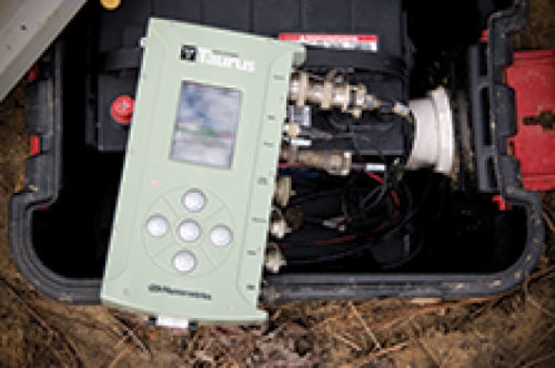

Any time a significant quake happens, Wagner’s seismometers record how much the ground moves as waves of energy come up from under the earth. When some waves hit a major change in the composition of the lithosphere, they scatter: some of the energy keeps on going straight up to the surface, while the rest shakes the ground from side to side as it rises. That scattering effect always happens where the upper mantle of the earth changes to the base of the crust. So the difference in speed between the primary wave and the shear wave that follows tells Wagner how thick the crust is under her stations.
Wagner has half a dozen seismometers spread out in a line from the North Carolina-Tennessee border down past Mount Mitchell and ending east of Asheville. Finding a good spot to put a seismometer isn’t easy, she says. The device runs on solar power, so the location has to be sunny year-round. Tractors, large animals, and well-traveled roads all create too many vibrations, so she has to stay away from those — also from the Southern Rail, which is never all that far away in the North Carolina mountains. And the seismometer is housed in a thirty-gallon drum that sits just under the surface of the ground, so Wagner had to find landowners who were okay with her digging on their property, and who would let her or her students come out every three to six months to dig the electronics box up and retrieve the data.
In one part of the Blue Ridge, UNC’s geology department happened to have a contact, a mineral collector who was happy to let Wagner stick a seismometer in the ground on his land. After that, she pored over a terrain map, looking mostly for spots that were up on ridges, away from major roads and the shadows of mountains, but looked like they were accessible by car.
“Then I just went knocking on doors,” Wagner says. When she found a landowner with a likely site, she’d introduce herself and explain that she was interested in finding out what the mountains were doing deep underground. Most people were friendly enough and willing to help. At one farm, a herd of baby goats escorted her and her students around the property as they worked. At another, Wagner came home from a data retrieval trip with cartons of free chicken and duck eggs in odd colors.
The seismometers have been in the ground since the spring of 2009, and there were enough major seismic events that year — earthquakes in Italy, others in Chile and Bolivia, some events around the Aleutian Islands and in ocean ridges — to give Wagner and her students the data they needed to map the crust. They got a clear result: the crust underneath the mountains is thick, disproving the high pressure, thin crust hypothesis. This means that the Appalachians follow the iceberg model. And there’s still so much crust left for them to use up that it suggests the mountains aren’t eroding nearly as fast as scientists have thought.
Wagner was satisfied with that result. But as she was preparing her data to present to colleagues at a conference, she found something strange: the pictures from her two easternmost seismometers showed that the structure of the lower lithosphere looks very different on either side of the Brevard fault, an ancient, shallow structure that runs in line with the mountains.

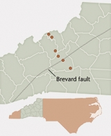
The lower crust and mantle underneath the mountains is supposed to be a relatively homogeneous mass from one ancient source. As you move east through the state, the ground changes: different bands of terrain got tacked onto the coast as the North American continent was being formed. If there really is a major discontinuity at the fault — and every seismic wave that rippled through the ground to Wagner’s seismometer seems to confirm it — that would shake up our understanding of where a huge chunk of rock underneath North Carolina came from. “This isn’t what any of the models say about how this part of the country was formed,” Wagner says. We won’t know for sure until more seismometers collect data on the east side of the fault.
Wagner has been using six of the ten seismometers she owns on her Appalachian Mountains research. The equipment is expensive, the waiting lists to use government-owned seismometers are at least a year or two long, and she’s always working on several projects at once. So after Wagner had enough data to publish her results, she was planning to move all her seismometers in the summer of 2010 for a round of data collection in the Andes.
But now she thinks she may just need to keep one foot in the North Carolina mountains.
Lara Wagner is an assistant professor in the Department of Geological Sciences in the College of Arts and Sciences. She received support for her work in the Blue Ridge Mountains from the John and Barbara Rogers Fund for Geochemical Excellence.