


The Galapagos Islands are under attack.
Invasive plants and animals, once foreign to the archipelago, are overwhelming landscapes and threatening the existence of unique native and endemic plants and animals, including those famous giant tortoises for which the islands are named.
Humans caused this problem. And geographers Steve Walsh and Carlos Mena hope that humans can solve it.
For centuries, people have been introducing foreign species into the archipelago’s fragile ecosystem. Pirates, whalers, and sealers released goats and pigs for food sources for return visits, and these animals trample plants and eat tortoise eggs, imperiling ancient nesting grounds. But some of the most damaging invasive species arrived after Darwin’s maiden voyage in 1835. Ecuadorian settlers brought several species, including cattle, guava fruit trees, and blackberry shrubs called mora.
“But the guava and mora got away from the farmers,” Walsh says. “And now these plants are in the national park.”
When animals eat mora and guava, they don’t digest the seeds. Some of these seeds eventually sprout. Also, guava’s roots are laced with seeds that quickly germinate.


“Guava is choking landscapes, changing natural grasslands into extensive guava forests,” he says. “They’re overtaking indigenous flora and fauna that appear no place on Earth other than in the shadows of the islands’ volcanoes.”
Although few endemic species have become extinct, the problem is so severe that the United Nations is considering listing the archipelago as a World Heritage Site “at risk,” which is causing the Ecuadorian government and conservation groups to take this problem seriously. Environmentalists have been battling invasives for years, but they’ve never been able to sufficiently map them or model where the plants might spread — until Walsh’s team visited last year.
Mapping the enemy
Walsh has been generating maps based on high resolution satellite images to document changes in land use and land cover in the Ecuadorian Amazon since 1997, working with CLIRSEN, an agency within Ecuador’s Ministry of the Environment. CLIRSEN agents asked Walsh if his technology could be used to map invasive land cover in the Galapagos.
In February 2006, Walsh visited the Galapagos with Brian Frizzelle of the Carolina Population Center’s Spatial Analysis Unit and Mena, a UNC doctoral candidate and citizen of Ecuador. Once they found invasive plants, they scanned them with a handheld field spectral radiometer, which measures the specific amount of sunlight that reflects off of various kinds of plants. The team used a plant canopy analyzer to document plant type, condition, robustness, and other characteristics. Then, using a fish-eye lens, they measured the crown density of the guava forest from below the forest ceiling — this added detail to help process and interpret the satellite images.
While still in the field, the team downloaded all the data onto a laptop, and then pinpointed their exact location with a global positioning system. Finally, back at UNC, they superimposed their data onto satellite-generated images of the islands to map selected invasive plant species in test areas.

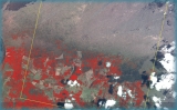
The work yielded the first-ever digital maps detailing how guava and mora are wreaking havoc, swallowing up thousands of acres of grasslands and threatening endemic plants. One area called the Sierra Negra is completely overrun with guava, and will likely never recover, Walsh says, because eradication techniques — such as spraying chemicals or pulling up entire plants — only work when guava patches are small and trees are young.
Although park conservationists aren’t trying to kill guava forests, Mena says, “What we can still learn from Sierra Negra is how the guava is spreading, so we can give scientists insights on how to control newer populations.”
Modeling the unknown
Last summer, Walsh’s team returned to the Galapagos to show their preliminary maps to environmentalists from the Galapagos National Park, CLIRSEN, the Nature Conservancy, and the Charles Darwin Research Station. The team collected more field data to validate previous work, and also taught environmentalists stationed in Ecuador how to use the same technology to continue mapping when Walsh’s team isn’t there.
“So far, our preliminary analysis shows where the invasive plants exist at a single point in time,” Walsh says. “We plan on building up a satellite time series to track the spread of these invasives, and then modeling the spread so we can show what the islands could look like in five, ten, or twenty years, and how the plants may respond to factors such as climate change and environmental policies.”
Walsh’s team will consider what-if scenarios and create models accordingly: what if park officials spray plants here or cut there? What if people introduce new invasives from mainland Ecuador? And what if more people come?
Models are crucial, Walsh says, because the interactions between people and the ecosystem are still evolving. Thirty thousand people now live on the Galapagos Islands permanently, many of them working in the tourist industry. In 1991, 41,000 tourists visited; in 2006, 125,000. With this influx have come more hotels, gift shops, boutiques, internet cafés, and restaurants — all in small areas restricted to four of the islands.
More human activity means more pollution, consumption, and stress for a famed ecosystem that had probably been pristine for millions of years. Yet, more tourism means more money for a developing country, and more confrontations between conservation and development.
And, as Walsh points out, farmers need to farm, and fishermen need to fish.
Walsh says, “If you’re looking to make money for your family to live, you might have a very different vision of conservation and development than if you’re a scientist or a resource manager trying to deal with fish and bird populations and their habitats. So this is a complex issue.”
Walsh formed a team of UNC ringers — from marine scientists and biologists to city planners and anthropologists — to research the problems and help him create long-standing research relationships with people in Ecuador who want the Galapagos Islands to remain a unique place.
“This work isn’t just about eradicating invasive plant species,” Walsh says. “It’s about trying to understand the story of invasive plants and animals as a people story. It’s about understanding how many people these islands can handle.”
Steve Walsh is a professor of geography in the College of Arts and Sciences and a fellow at the Carolina Population Center. During his second visit to the Galapagos Islands, he was accompanied by Ron Rindfuss, Robert Paul Ziff Distinguished Professor of sociology, and Flora Lu, an assistant professor of anthropology, both fellows at the Carolina Population Center. Geographer George Malanson from the University of Iowa was also part of the team, as were Carolina students Carlos Mena, Amy McCleary, Julie Tuttle, and Patricia Polo. Walsh’s lab includes doctoral candidates Laura Brewington and Yang Shao. Walsh received funding from UNC’s Vice Chancellor for Research and Economic Development, College of Arts and Sciences, Carolina Population Center, Department of Geography, and the National Aeronautics and Space Administration.