The air is thick with humidity and the earthy scent of damp soil and decaying plant matter as five researchers step off a flat-bottom skiff boat. They wade through the murky waters of the Currituck Sound in search of the spongy ground of the nearby marsh.
Once on shore, the soft squelching sound of their footsteps blends with the distant buzzing of insects. They navigate narrow, winding paths while carefully watching where they step to avoid sinking into the muck. With an aluminum pole and GPS unit hand, they begin to mark elevation points along the marsh and record vegetation present on an iPad in a clear waterproof case.
“The sediments in the Currituck are really squishy [and] slimy,” says Peggy Mullin, a UNC-Chapel Hill master’s student. “Getting stuck in the marshes is just part of the job.”

The research team records data from the marsh. (photo by Megan Mendenhall)
This past summer, researchers from the Carolina Drone Lab — a collaborative research unit within the UNC Institute for the Environment — visited four marsh sites along the Currituck Sound as part of a study on the applications of drone technologies for coastal resilience and habitat monitoring.
They are partnering with Elizabeth City State University (ECSU) and Audubon of North Carolina to aid in understanding the status of the marshes and the future management of the sound.
“Our partnerships are very important,” says Troy Walton, senior research scientist and lead pilot for the lab. “ECSU has a great aviation program and a wide variety of drones, which allows us to have another data set for comparison. Audubon owns the property that we’re collecting on and they’re leading the restoration efforts.”
High-tech conservation
Marshes are important for many reasons. They help to reduce the impact of flooding in coastal communities by absorbing and storing excess water. They filter water and prevent erosion. And they provide a habitat for a variety of wildlife, especially waterfowl, which draw tourists to the Currituck Sound each year, supporting the local economy.
But the sound is changing drastically. Nearly 72 acres of marshes in Currituck County are lost every year due to the combined effects of erosion and sea level rise.
“We saw an aerial image that was taken in the mid-60s, and one of the sites that is currently being assessed for restoration used to be one large complex,” Walton explains. “Now, it’s totally fragmented into many different, smaller sections, and it’s just trending more and more in that direction. So if nothing happens that marsh is going to end up drowning in the very near future.”
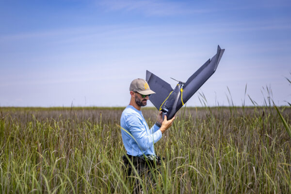
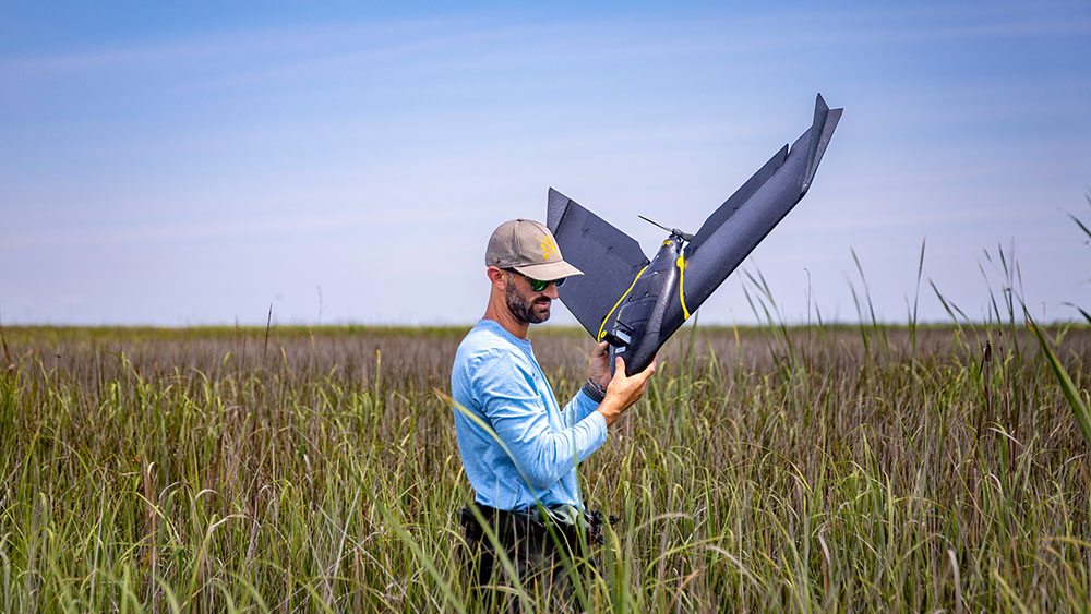
Troy Walton recovers a drone from the marsh. (photo by Megan Mendenhall)
To help protect and revive marsh habitat, Audubon of North Carolina is undertaking a series of sediment restoration pilot projects at the Donal C. O’Brien, Jr. Sanctuary and Audubon Center at Pine Island. This involves thin-layer placement, where sediment dredged from the sound is applied to the marsh surface to elevate the land.
The current methods to track marsh health overtime often use satellite imagery to show the overall trajectories of marsh erosion and movement — but those tools provide poor resolution and incorrect scales.
This is where the Carolina Drone Lab comes in.
“Drones are a great tool for this project,” Walton says. “We’re flying with super-high resolution, with different types of cameras that will tell us the actual marsh health based upon the reflectance that we’re receiving back from the multispectral camera.”
By stitching together over 1,000 drone photos, Walton and his team can create an image of the marsh with centimeter accuracy.
They also use the data to create a digital surface model that shows the elevation across the marsh and to understand if the elevation of the marsh is keeping up with local sea level rise. Then, they compare that data with elevation points collected on the ground using a handheld GPS unit to verify its accuracy.
“This research benefits the citizens of North Carolina because the marsh problem is not just localized to Currituck sound — it is across North Carolina and the world,” Walton says. “If we can better understand what’s happening here, then we’re able to take these strategies and expand them to the state and then hopefully further beyond that as well.”
SAV-vy solutions
While the larger project in the sound is focused on how sediment helps marshes survive, Mullin — a Carolina graduate student studying ecology — is examining the problem from a different angle. She wants to know how submerged aquatic vegetation (SAV), or underwater plant life, affects the marsh.
SAV is a vital component of aquatic ecosystems. It provides habitats for fish, invertebrates, and other marine organisms, while also improving water quality by absorbing excess nutrients. Additionally, SAV roots can stabilize sediments, reducing erosion.
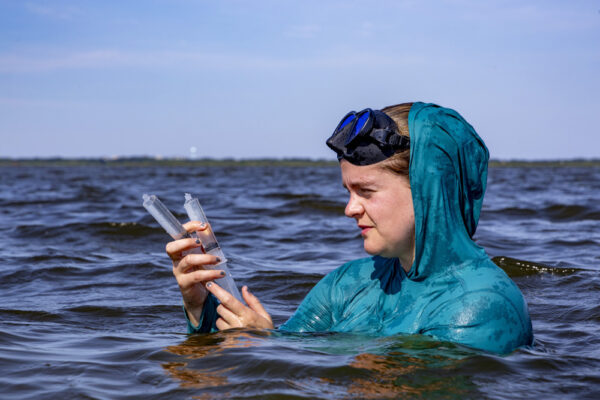
Peggy Mullin collects water samples from the sound. (photo by Megan Mendenhall)
“So, there’s kind of a conversation right now about whether SAV has sediment-trapping abilities or whether it’s a sediment provider to the marsh,” Mullin explains.
To investigate this, she pilots a drone equipped with a specialized camera to detect SAV in the water. Then, she goes out into the marsh to observe the types of vegetation living there and along the shoreline.
“So that meant kind of ducking down, diving down, characterizing what sediments we were seeing, characterizing what plants we were seeing, and getting a feel for turbidity and water clarity and depth,” Mullin says.
Overall, she wants to determine if remote sensing tools are useful to detect and monitor SAV.
“Once we figure out whether or not that can be done, that will have a lot of impacts on coastal monitoring and for the future of North Carolina’s coasts,” she says.