“You know the ice is moving when you can hear the river before you can see it.”
I said this to UNC research specialist Camryn Kluetmeier as I parked our comically large SUV in a gravel lot next to the Tanana River. We grew quiet and listened. Beneath the shouting seagulls and rustling dead grasses still standing after the winter’s snow, there was a new sound: a deep grumble.
And for us, it was music. We’d been waiting two weeks for this.
I ran up the levee and stared in awe at the river before me. What had been a silent, smooth white expanse had transformed into a jumbled mess of angular brown, white, and blue chunks of ice tipped sideways and smashed together in the pulsing river below. The spring ice breakup had started. It was beautiful, powerful, and dangerous.
April 2024 marked my second spring spent in Fairbanks, Alaska, waiting for the river ice to move. Ice breakup is a hard thing to predict — but that doesn’t stop hundreds of people worldwide from placing bets in the annual Nenana Ice Classic. While we aren’t the betting type, we hope our scientific approach might provide the most accurate guess.
We plan, poring over historical data and this year’s climate projections, and then cross our fingers that we’ll catch it: this brief, chaotic, dynamic part of the river’s annual cycle.
We’re a group of scientists from UNC-Chapel Hill, Oregon State University, and University of Alaska Fairbanks (UAF). As a team, we work in all seasons on the Tanana River to understand how much sediment — sand and mud — moves though the river in different parts of the year. My role as a PhD candidate in the UNC Department of Earth, Marine, and Environmental Sciences is to try to measure this sediment as winter ends and ice melts.
Sediment signals
The Tanana River slowly moves mountains, one grain of sand at a time, to the sea. Starting from mountain glaciers near the border between Alaska and Canada, it picks up and leaves behind new layers of the landscape as it flows. In summer, the swirling, muddy river resembles chocolate milk more than a glass of water.
The journey ends at the coast. There, mud and sand build and reinforce the shoreline, counteracting sea-level rise and preventing the erosion that threatens coastal habitats and forces communities to relocate inland.
Right now, estimates of how much sediment is reaching the coast are primarily based on measurements collected during the short, ice-free summer months. This is when the river’s flow is the strongest, with glaciers upstream melting and flushing tiny bits of rock downhill.
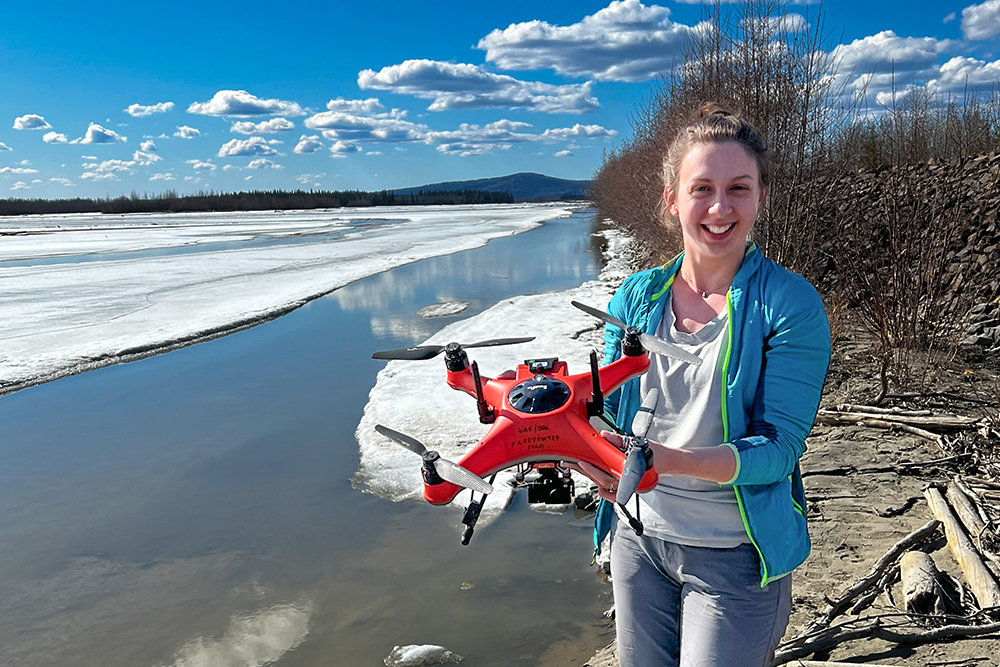
Julianne Davis prepares for a drone flight over the Tanana River. (photo by Camryn Kluetmeier)
It’s also the safest, easiest time of year to collect data. But we want to know what’s happening during the other seven months of the year. And, right now, what’s happening as the ice starts to melt and break.
In spring, melting water carries extra sand and mud into the river and can increase water pressure under the ice. As that pressure rises, turbulence stirs mud up from the riverbed. Once the ice finally cracks, the broken chunks carve away banks as they lurch down the river.
All this activity means that the amount of sediment in the river might be high. If that’s true, then this short period could reveal important information that we’re missing on most icy rivers.
But the river is treacherous, making it a difficult time for data collection. It doesn’t help that most sensors that can measure sediment are expensive, $3,000 each, and there’s a good chance they’d get swept away.
Step one to solving this problem? Send a robot — a.k.a. a drone — to do the dangerous work. Step two: Replace the expensive sensor with a cheaper, DIY one. Step three: Ask the locals for help.
Floaties and flights
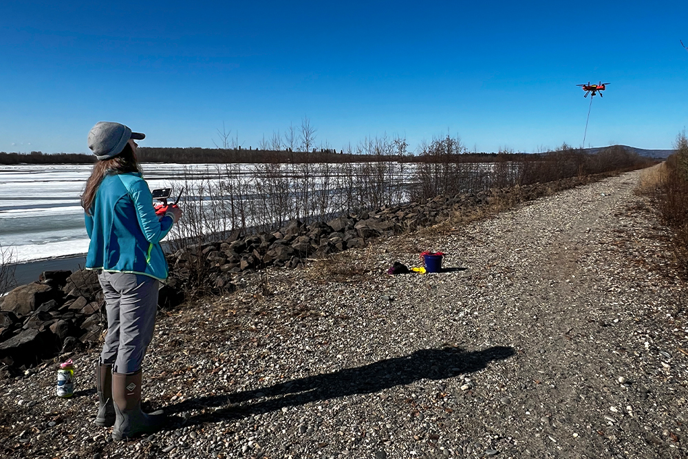
Everyone walking by pauses to see what we’re doing. Our scientific setup does look strange: three women standing on the riverbank watching a bright orange drone dangling a 15-foot line with a sensor on the end over a jagged hole in the ice. Just above the sensor, we’ve tied a teal arm floatie. I’m confident that I’m the only person buying children’s floatation devices in April in the middle of Alaska.
But, as several school-aged children showed me during a STEM workshop at UAF, a float was an ingenious addition to our setup. It makes sure the sensor reaches the same water depth every time we make a measurement. And the bright colors help us see the sensor when the drone is far away over the river.
As always, we guess how much sediment we’ll measure in the water before we begin sampling for the day. My advisor, Tamlin Pavelsky, started this tradition.
“I think it’s still low today. The ice hasn’t started moving yet. Maybe 30 NTUs,” I say.
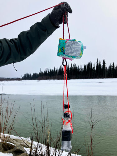
In 2023, Davis workshopped her project with Alaskan elementary school students, who recommended she attach a floatie to her sensor so that she could always find it in the water. (photo courtesy of Julianne Davis)
NTUs are measurements of turbidity, or how clear the water is based on how much material is mixed in it. It’s how our DIY sensors measure sediment. First, they emit infrared light. Invisible to our eyes, this light will then bounce off the sand and mud particles in the river water. The amount that bounces back to the sensor tells us the turbidity.
My prediction is close. In summer, we often measure turbidities that are more than 10 times higher than this. So, if there is a sediment pulse during ice breakup, it hasn’t started yet.
My heart races as I maneuver the drone and sensor into the sky again. The work is challenging, relying on the small camera feed of the drone’s perspective to find open water zones in the ice and timing the descent so the sensor stays in the water long enough — eight seconds at least — but isn’t pulled too far by the fast current.
Fun has replaced fear. It’s like a game, flying the drone more than a football field’s length away over the river, then carefully finding the right time and place to dip the sensor into the water. All the while, the rest of the field team watches for any low-flying birds or moving ice chunks that could trap the sensor and makes sure we have enough battery for the return flight.
We usually win this game. Our prize is threefold. First, the data. Every day, we get to see how the river turbidity changes. It’s immediate gratification. Secondly, we record each flight and, when reviewing the video, I’m in awe of this perspective of the constantly changing landscape. Lastly, once all drone batteries have been depleted, we can just watch the river.
As the ice breaks and is swept downstream by the current, a section of river can empty of ice in just minutes. Trapped ice floes spin in the water. Chunks smash into the riverbank, either shattering apart like falling icicles or scraping bits of land back to the water. If I close my eyes, the sounds almost make me think I’m at the beach, listening to waves crash on shore. I could watch for hours.
We don’t always win, though. In two seasons, we’ve lost one sensor and one drone. A faulty clamp dropped a sensor beneath the water in 2023. This year, on our first day of work, the drone flew away.
A year ago, this loss would have left me in tears. Now, I gasp and then laugh. Everyone is safe, we found the broken drone, and thankfully, we have backups.
Ice inquiries
My annual Alaska trips have come to an end. We are in the final stages of this project, the remaining drones are packed away, and now, the data processing can begin.
The first, and perhaps most important question to answer, is this: Is there an ice breakup sediment pulse? Maybe! Over just a few days of ice movement, turbidities more than tripled. But we still need to compare these data to summertime sediment levels to understand if this brief, yet powerful, period is unique compared to the other days of the year.
How the river ice breaks is changing. Ice breakup can either be thermal — when the ice slowly melts and turns the top of the river into brown slush — or mechanical, when the ice cracks before it melts too much. We’d expect more sediment in the latter case, when the ice stays stronger for longer. With climate change, river ice break up is happening earlier, more often, and thermally, with more ice melting before it breaks.
Some questions remain unanswered. If the future keeps moving toward this melting world, as it is almost certain to do, what does that mean for the river? If less sediment moves in the spring, then less mud and sand might reach and reinforce the Arctic coasts.
At a larger scale, though, what will the world’s rivers look like when there’s less ice covering them? We can’t answer that question yet. But what we can do — what we are doing — is marking, sharing, and preserving this unique moment in time on the Tanana, hoping it will help us better understand our future.